Click on the graph for a current snow conditions.
Snow (Water Content) Graph
Click on the graph for a current snow conditions.
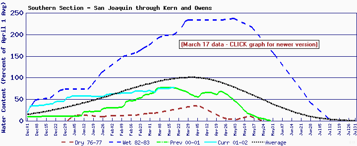
The above graph is published by the California Department of Water Resources. It shows the snow water-content (amount of water held by the snowpack) as a percentage of the April 1st average. (The average maximum of snow water-content accumulation.) There are three graphs on their website ... Northern, Central and Southern Sections. The Southern section is posted here (through March 17th). It covers the Kern and Owens watershed areas (PCT area north of Kennedy Meadows).
The black line shows the average snow water-content percentages (note 100% is at April 1). The blue line is the wettest year (maximum) and the brown the driest year (minimum). The green line is last year and the current year is in cyan.
As PCT hikers, the desire is to have as close to "normal" a year as possible. Too much snow creates hiking hazards (slippery footing, difficulty in following the trail, difficult hiking, avalanche danger, & heavy meltwater). Too little snow has its own problems (dusty and difficulty in finding water).
The 2001-2002 year started off with a BANG and in early-to-mid December, it looked like we were going to be up to our hips (or higher) in snow! Snow accumulation has been slowing since then, however, and now (in the southern section, at least) it appears that we are going to experience a below-normal accumulation of snow. There still could be some late-season storms that change things, but right now, that's how it looks.
Note that water-content does directly translate to snow DEPTH. Light, fluffy, dry snow holds much less water than dense, heavy-packed snow. If colder temperatures prevail, the snow can be quite deep. Still ... this graph provides a good idea of the type of travel we will be looking forward to in the Sierra.