"Let it Snow, Let it Snow, Let it Snow"?
Like all things in life, "timing" plays a critical role in the success of a PCT thru-hike. No matter which direction you travel, Canada-to-Mexico, or Mexico-to-Canada, the approach of winter limits your available hiking time. The direction of travel, however, is a sort of Earth-bound "Doppler-effect". Traveling north, you follow spring into the northern latitudes, trying to get to Canada before the onset winter - EXPANDING the hiking season. Traveling south, you can't start as early and you're still worried about the onset of another winter, albeit somewhat later, in the southern sections of the trail - effectively COMPRESSING the hiking season. Most thru-hikers travel south-to-north and we chose the same, less difficult, option.
Another factor in the quality of a thru-hike of the PCT has to do with the winter season preceeding the hike. Above average snowfall poses many problems: mountain passes may be buried and impassable, the trail will be difficult or impossible to follow when it is buried under mounds of snow, river fords are dangerously swollen with meltwater and the trail may be treacherous because of icy slopes with boulders below. Below average snowfall poses another problem: lack of available water. Thru-hikers hope for a normal snow year and keenly watch as the winter season preceeding the hike unfolds. Decisions about start dates, clothing, equipment and High Sierra entry are all determined by the preceeding winter season. If a big snow year is developing, ice axes, crampons and maybe, snowshoes are purchased. More thought is given to taking cold weather clothing. The start-date for the hike may be pushed back or, the new plan will be to hike to the High Sierra and then "flip-flop" (bypass the snowed-in High Sierra and skip ahead to Canada, travel south and finish the hike in the High Sierra, well after the snow has melted). If a drought year is unfolding, perhaps the start-date is changed to an earlier date and more thought is given to extra water carrying capacity and water location.
You don't plan a 6-month thru-hike of the PCT a week before you go. For us, we began seriously acquiring equipment, dehydrating food and living the PCT cable-channel life just after Christmas ... fully 4 and a half months before we were due to leave. (Some plan in less time, but I suspect that there is a correlation between thru-hiker success and preparation-time. We'd like to think so, at least.) We picked a start date of April 15th, just to have a target. We felt that this would put us on the trail before the hiking season (the AZDPCTKO - 'Annual Zero-Day PCT Kick-Off' - party, held in Lake Morena, near Campo, iss usually scheduled for late April and marks the unofficial "start" to the year's thru-hiking season). We wanted to leave ahead of the big "slug" of thru-hikers attending the bash. Not that we're anti-social, we would just prefer to be among the first hiking into the trail towns along the way. We also have plenty of friends and family in California, so heck, if it was going to be a big snow year, we figured we could always find someplace to lay up for a week or two - however long it took till the snow melted a bit. An April 15th start date also put us in the desert section early, avoiding the heat and increasing the probability of capitalizing on vernal water sources.
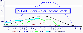 |
Click on graph for a larger version. |
While it sounded like a good game plan, it didn't stop us from worrying about snow! Especially because the 2001-2002 snow season started off with a cannon-shot of a BANG! Just look at this graph, which compares current snow water content (important to the economy, recreation and life-blood of California) against drought and heavy-snow years. At Christmas-time, we thought that we were going to be a couple of Yeti's ... hiking across barren snow-covered peaks and valleys. We worried about when we should leave (should we wait till later?) and what we should take (crampons, ice-axe and snowshoes?). Some people advised to quit worrying ... what will be, will be. In the meantime, we read a very encouraging article by Chris Bailey titled "Impassable is a State of Mind". He and his hiking partner, Jenelle Wilhelm, thru-hiked in 1998, which was a BIG snow year in the High Sierra. We found what he had to say encouraging.
It didn't, however, stop us from worrying. (Isn't that what long, dark winter nights and short, grey winter days are for?) We found even more places on the Internet to confirm our fears and validate snow accumulation in the High Sierra. (For those interested in the gory details, see our Planning Links section). One that we particularly liked, however, was the watershed (map version) of similar data put out by the Natural Resources Conservation Service of the US Dept of Agriculture ... heck, it's just colorful! It's a snapshot picture of accumulation (I believe that it is, also, based on water-content). The maps are done on the first of each month and you can click on the map below, go to the web site, and select the most current map. (Their maps cover the western U.S. - I edited the March 1st map to show only the PCT states, i.e. California, Oregon & Washington).
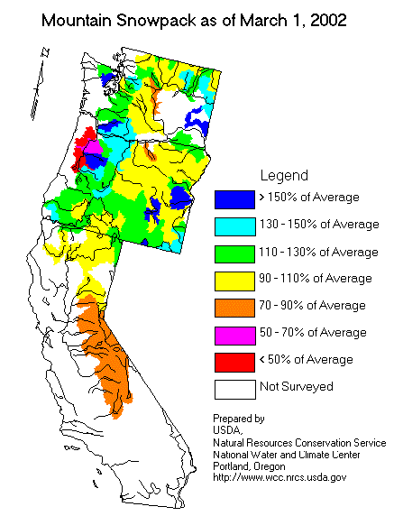 |
Click map to open NRCS.USDA snowpack folder |
As we write this part of our web site, we are in the midst of moving out of our apartment and only about 3 weeks from our start date (today's date is Tues, March 26). Unless there is a huge winter storm rolling in soon (which could happen), it appears that our hike is going to be during a "slightly less than normal" snowpack year (at least in the Southern Sierra). By no means does this mean that we won't see snow. Most literature that we've read indicates that any sort of PCT hike will involve snow, it's just a matter of degrees - more ... or less. What it will likely mean, however, is that the water season in the south (deserts) will be quite retarded. Vernal springs and ephemeral streams will cease to flow earlier. It is a good thing that we are leaving Campo a bit early.
What gear will we take? No snowshoes. We are hoping not to "post-hole" too badly when we do run into rotten, soft snow. Hopefully, it won't be too deep in the High Sierra, but if it is, we'll hike early in the morning, while it is still firm. We will take ice axes. They are our insurance policy. Who knows what conditions will be like in the High Sierra, or mountains further south (Mt. San Jacinto & the San Gabriel's), for that matter. If we do encounter icy conditions, our ice axes could mean the difference between life and death (or broken leg(s) or sprained ankles) ... all of which would not be good. (Especially the death part!) We're going to be taking Camp HL-250 ice axes. They are very light (9 oz or so) and on the longish side (70 and 80cm). Great for hiking, but not really strong enough for mountaineering work (which is fine by us - we just want to use them for 'self-arrest', not tethering a roped climbing team). We looked at several crampon options, all the way from YakTrax (super light-weight) to Stubai Crampons (mountaineering quality). We ended up going with a sort of middle-of-the-road options ... instep crampons. They are much lighter weight than the mountaineering crampons, but provide solid gripping power, unlike the YakTrax, which are likely to come off the boot at some critical juncture.
We hear that the Sierras are getting some snow right now! Maybe it will be a normal year ... maybe above normal ... maybe below normal. Who knows? All we know for certain, is that we'll be hiking in snow, no matter what happens. As John Muir was heard to say, "Watch out where those Huskies go, don't you eat that yellow snow!" (He was such a wild-man! Clinging to the top of a pine tree in a huge storm ... I bet he'd be into extreme skiing if he were alive today.)